
La Ravoire and Sardinian Way from la Grotte
Starting point: La Grotte Difficulty: 1 Ascent: 245 m Time: 3 hrs Quality: **
This is a stroll around the woods of the Ravoire plateau which lies between between the Sardinian Way gorge, and the Gorges de l'Echaillon through which the Guiers Vif flows, near Les Echelles (map). Besides being a very pleasant walk, it also takes in a number of the local sights which are worth a visit in their own right. It's not a long day, but it can be extended by visiting the Grottes les Echelles show caves, or having a swim in the lido in Les Echelles.
We start from La Grotte, a small village at the end of the Sardinian Way, There is ample parking in one of the two car parks south of the chapel, that in the enclosure under the cliffs probably being the best. There are a couple of information boards, where you can get your bearings, and picnic tables where you can breakfast.
At the back of the car park, the way is along a track heading south behind the houses. This joins a residential road after 250 metres, which soon merges with the D46. After a further few metres there is a lavoir on the left, and the way up onto la Ravoire is a path heading up behind this. However, initially we continue along the road round the corner to be confronted by the remarkable Pont Romain. This incredible structure obviously does not date from the Roman period, but nevertheless, it is an ancient packhorse bridge that linked France with the Duchy of Savoy. If you cross the bridge, there is a path continuing up the gorge for a couple of hundred metres or so that offers some impressive views.
Returning to the lavoir, locate the path heading up into the wood. This is the GR9. It rises gently for ten minutes before reaching a junction. Straight on leads into the gorge, and our way is to the left, up through the cliffs, using a series of remarkable steps carved into the bedrock. Once it reaches the plateau, it follows the edge of the gorge to a signposted junction, "Les Charmilles". We stay with the GR9 along the edge of the gorge, which offers an occasional view of the dramatic cliffs on the far side. Eventually, the path reaches a cross-roads, recognisable from a well marked tree. Here we keep left, along a pleasant forest track. Ignoring a track to the right, a T-junction is met where we turn right along a metalled track for 100 metres. Here we meet a major junction, "Les Charmilles", where we leave the GR9 to the left to visit the Belvédère de Gerbaix. This track ascends steeply at first, but soon flattens out. Ignore the tracks joining from the left. Soon after the second, the track becomes a path and encounters another signposted junction at "Bois de Ravoire". We carry on, and keep left after another 20 metres to arrive at the belvédère.
The belvédère is a fine view point overlooking Le Villard, with some interesting information boards highlighting the climatic changes in the area following the last ice age. It's also a good place for lunch!
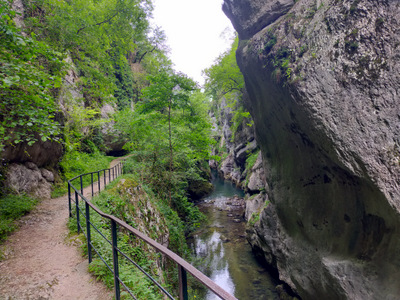
The next section of the walk isn't marked on our IGN map (2015), but it is clear enough underfoot. Take the northerly exit from the belvédère, and follow the lovely path which meanders through the wood. In one or two places the way on isn't immediately obvious, but just look out for the yellow waymarkings. At one point there is a junction, with a path going down the hill off to the right. We keep left. Another signposted junction is met shortly after, "Sentier de Chèvres". We turn right towards the "Voie Sarde", the Sardinian Way. This rather unexpectedly descends into the gorge by means of a series of metal stairways.
The Sardinian Way is an impressive place. Providing a natural route out of the mountains onto the plain, the road through the narrow gorge was originally built by the Romans, and then extensively renovated in about 1650 by Charles Emmanuel II, Duke of Savoy. It features a superbly paved surface, and a canal which was designed to keep flood waters emerging from the upper cave away from the road. There are two show caves in the gorge, the upper cave at the head of the gorge, and the lower cave near the bottom end.
The lower show cave is close to where the road swings left past a formidable monument that personifies self-aggrandisment, to descend to the plain on a massive walled terrace. Part of this was destroyed by the French in the Second World Wall in an attempt to slow the progress of the German army. Just below the partially repaired section, a large clearing has two cave entrances - one behind, and one on the left, both gated to protect their bat populations. The latter, the Grotte de la Glacière, is the most interesting. We once went in before it was gated, accompanied by a local dog who took it on himself to be our guide. A large passage headed straight into the hill for about a hundred metres until the way on was blocked by boulders.
From the clearing, continue down the Sardinian Way for a further two hundred metres to find a track on the left which doubles-back to the car park.