
Dent de Crolles via the Pas de Rocheplan
Starting point: Les Eyrauds Difficulty: 3 Ascent: 1150 m Time: 7 hrs Quality: ***
Although there are plenty of routes into the massif from the eastern side, there are few that lend themselves to circular walks, and hence they tend to be rather unsatisfactory. This is one of the few walks in this guide that does ascend the eastern flanks, and also allows an aesthetically satisfying circuit to be made (map). It is not, however, a walk for the faint hearted, requiring a descent of the Cheminée du Paradis, as well as a relatively challenging walk round the nose of Dent de Crolles on a traditional, but little-used path, both of which merit a Difficulty 3 classification. But despite its difficulties, it is rewarding and worthwhile.
The walk starts from the car park (not marked on the IGN map) at the skiing station les Eyrauds (970 m grid ref. UTM 31T 72620 50220), off the D30. Follow the track that runs just above the cemetery for a few minutes to a tarmac road, and turn left up the hill. This soon turns into a steep forest track, which improves after a few minutes.
A new hard-core road has appeared on these slopes which is not marked on the map, and we encounter it for the first time at a confusing five-way junction some 25 minutes after leaving the car. Follow the way-marked path which is the third from the left. Over the next 20 minutes, we have to cross this new road two or three more times, until we reach the Source du Sanglier (1282 m), an extraordinarily ugly covered reservoir, with the Pas de Rocheplane signposted straight ahead. We are now on our way.
The rest of the route up to the crest is superb. It starts off steeply, but soon slackens off. Some 15 minutes after leaving the reservoir the path passes below an outcrop of orange limestone - le Truc. Shortly after it emerges from the forest, and starts on an exhilarating section of path which rapidly surmounts the rocky ramparts to reach the Pas de Rocheplane some 2 hours or so from leaving the car. The path is obvious throughout this section, but towards the top it does require a little mild scrambling (Difficulty 2).
It is always good to reach the crest, and in this case the views suddenly open up all round, with the full extent of the Dent de Crolles massif in view, and the Perquelin valley and the Grand Som beyond. Immediately on the right is a large pinnacle.
From the top, two paths head off towards the south - one along the crest and the other just below. The latter is easier walking, and wanders exquisitely through a wonderful meld of rocks and flowers.
The start of the Cheminée du Paradis section is heralded by a line of trees. There are a couple of ways of getting to the chimney, but the easiest way is to follow the waymarkings down a rocky barrier, and then bypass the large drop in front by immediately regaining the height by climbing up to the left. The path then descends an easy gully to the right, to the head of the chimney.
The Cheminée is an impressive cleft, about 10 metres high, ten metres deep, and less than a metre wide, which is descended in three steps. There is no significant sense of exposure, but the holds are a very polished, and a little awkward (Difficulty 3). A safety line may be useful for people who lack confidence in such places, and is definitely useful for lowering packs down.
At the bottom, take the path that starts by trending down and follow it to the summit of Dent de Crolles (2062 m), reached about hour and half after leaving the Pas de Rocheplane.
On a clear day, the views from the summit are spectacular. The Belledonne hills can be seen over the haze-filled Isère valley to the east, and 100 kilometres to the north-east, the white mass of Mont Blanc seems to be hovering in the sky. To the north, west, and south, the Chartreuse massif fills the near and far horizons.
Our descent is down the Pas de l'Œille which follows the fault gully descending through the cliffs some 100 metres north west of the summit, and has a prominent pinnacle near the top. It is quite straight forward, apart from being steep, but it is a little loose in its upper reaches. Its descent does include a couple of steep rocky sections, but these are quite easy, and furnished with cables.
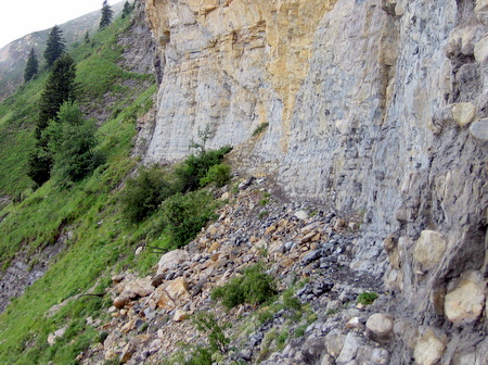
Continue down the path until about 20 metres from the junction with the Trou du Glaz path. Here, look for a thin line crossing a shallow scree gully on the left. Follow this, and on the other side an obvious path starts a gentle ascending traverse of the hill. At times, the path is obscure, and divides - however, just keep an eye open for the main line. This eventually meets a very prominent path running down the Ravine de la Gorgette - a yellow, decaying feature. This is the start of the Pas des Terreaux. Enter the ravine, and follow the obvious route that traverses round its head. Care is required, as the path is a little nominal at times. On the far side, the path eases as it approaches the nose of the South Pillar. This section was subject to a massive rockfall in October 2010 which took out 150 m of path, so be warned! The most impressive section is after the path rounds the nose of the cliff, where you will be traversing on shale ledges. You should listen out for stones falling from the cliffs, all along this path. They do give fair warning by whistling at you during their descent!
Once off the shale ledges, the path passes beneath the entrances to the Grotte Annette and the Grotte Chevalier. After this the path becomes a little more relaxing, although it does have one or two interesting little traverses across the top of the occasional gully, Eventually, the path begins its descent away from the cliffs. The start of civilisation is marked by a Franco-Incan ruin (you'll believe me when you see it!) which presumably is associated with avalanche control, and the Cabane du Berger, a small unwardened refuge from which there are good views of the summit cliffs.
The path has now turned into a track, and it drops rapidly down to a junction reached after 20 minutes. Turn left, and after a few minutes it crosses a piste to become an excellent thin path traversing the hillside, with red and yellow way markings. This continues for half an hour, a little overgrown in places before disappearing under the new road encountered earlier in our walk. Turn right at this, and round the sharp bend to the left, and continue along the road for ten minutes past a junction, until you pick up the original ascent path heading down. The car park is now just a 20 minutes stroll away, from where you will be able to pick out your ascent route.