
Dent de Crolles - Cirque Sans Nom
Starting point: Perquelin Difficulty: 3 Ascent: 800 m Time: 6½ hrs Quality: ***
Anyone who has spent much time on Dent de Crolles cannot fail but be intrigued by the large cirque into which the plateau's synclinal basin plunges. It looks as if a large mouthful, some 500 metres long and 350 metres across, has been chomped out of the hill, the north walls of which are topped by Le Prayet, and the south by the Belvédère. Its overall architecture is probably best appreciated from La Scia, but the finest views into it are from the GR9 as it approaches the Cheminée du Paradis cliffs. Here one can appreciate the size and seeming impenetrability of the place. However, there is a route into it from the bottom, which manages to exit in the north-east corner. It traverses pathless terrain, and includes a couple of awkward scrambles, and for that reason it deserves its grading. It is a must for Chartreuse aficionados, but is probably best left alone by the less frequent visitor. The route only scratches the northern side of the cirque, but it does allow access to the rest if you want to explore further. The walk then continues by descending through the Chaos de Bellefont, which is equally challenging, before joining the Sentier du Colonel which is the voie normale descent (see map).
The Perquelin valley is a narrow valley that runs south-east from St. Pierre de Chartreuse for about three kilometres to the hamlet of Perquelin. Drive to the top of the road, and at its conclusion, continue along the forest track for 100 metres, where you will find a car park (990 m grid ref. UTM 31T 72314 50237. Our first target is to find the entrance to the Guiers Mort cave.
From the car park follow the forest track past a clearing, until you cross the Guiers Mort stream, and also get a glimpse of its waterfall above. Immediately on the other side of the bridge, a path ascends pleasantly through the woods, passing the Fontaine Noire (also known as the Ruissea de Bellefont) - a captured water source which is the resurgence for the Chaos of Bellefont area above.
Continue on the path uphill for a few minutes, then take the next junction to the right (the way to the left is our descent track), which soon leads to a forest track. Turn right, and after 100 metres, turn left at a sign-posted path just before the Guiers Mort stream, some 10 minutes after leaving the Fontaine Noire. This path rises through the forest, until it descends to a set of metal "stepping stones" across the stream, with the imposing cave entrance (1310 m) above. You, however, carry on towards the cave entrance.
A path heads up the hill some twenty metres before the cables leading up into the entrance start. Take this, and follow it north under the cliffs. A small cave entrance is passed after a few minutes. The path then becomes lost under a mass of dead leaves and fallen branches, but some five minutes or so from the cave the angle of the cliff eases, and it is possible to scramble up the 10 m-high slope. (slippery when wet).
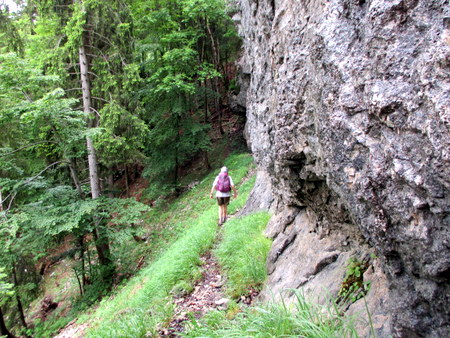
The next obstacle to overcome is a second cliff about 150 m from and 100 m above the first which should be circumvented on the left-hand side of the cirque. We have found two routes which get us to the appropriate place. Firstly, once at the top, trend generally half-left, and with a bit of luck a couple of cairns and thin trails will lead onto some scree below the northern flanks of the cirque. Here a thin path make an ascending traverse of the scree slopes. Alternatively, follow a thin line and some cairns leading into the forest for ten minutes, and when these give out, make your way north onto the same scree slope.
Some 30 minutes after leaving the scramble, a steep grassy slope is encountered which is ascended for ten minutes to a a couple of rocky barriers. Above this is a sweep of cliffs topped by a large overhanging promontory on the left. This is a good place for a second breakfast with a fine view of the Perquelin valley, although we had to retreat rapidly from this point when a herd of chamois started kicking stones down from the cliffs above.
From here make for the path that traverses scree below the cliffs (you can reach this point without going up the small rocky barriers), and then wend your way up a loose ascent into an upper cirque. There are again two routes up this. If you follow a path on the left, you get to a line of 10 m-high overhanging cliffs which you have to traverse under to the right for 100 metres before being able to continue up. A line taken directly up the scree / grass further round to the right avoids this.
At the top, about 20 metres from the left hand side of the cirque, there is a weakness in the cliff marked by a gnarled tree. It is possible to climb up here - alternatively there is a recess in the cliff a few metres to the right where a short climb onto a sloping ledge allows an even easier ascent. Above this a path leads directly to the GR9 and civilisation within 5 minutes.
The cliffs descending from the Cheminée du Paradis are immediately in front, and the GR9 follows a pleasant rake through them, and then traverses a steep bit of prairie. After a further 15 minutes you reach le Prayet, a flat meadow area with a well decorated tree. You can retreat down the cirque down the Sentier du Colonel on the left (not signposted) at this point. This connects with the recommended descent route after 10 minutes or so.
We continue along the GR9 into the Chaos de Bellefont, where the path picks its way between rock faces and shafts. After about quarter of an hour, the path opens up a little passing through an area more grass than rocks on the right, and very shortly after a path will be seen going back underneath marked with a cairn and a bold red and yellow arrow pointing in our direction. Take care with this path - although equipped with many large waymarks, they are there to aid the ascent and they are not always obvious in descent. Be vigilant, and make sure that one is always in sight.
The path continues straightforwardly until an impasse is reached where it seems to plunge into a rock crevasse. This marks the approach to the Z-Couloir, so called as it is a deep cleft formed along three joints in a Z shape. The way into it is an easy climb up the 3 m-high wall on the left, indicated by an arrow, onto a platform with steep drops all round. Make your way to the far end where it is possible to step down onto a ledge a metre below the platform. From here, a scramble leads off to the right down to a chockstone perched above the first stage of the Z-Couloir. It is now possible to climb down into the couloir. Turn left into the next section, and follow it to the third across two small shafts with log bridges. This section finishes down a 4-metre scramble at the end where care needs to be taken as there is a shaft to one side of the rather polished landing.
The next stage defies description, descending through a maze of crevasses, huge boulders, and cliffs. Do NOT loose the waymarks! Eventually it starts to make its way south descending below a cliff, and morphs into a pleasant sangle path which is followed for some 20 minutes until it reaches the junction with the Sentier du Colonel descending from le Prayet. This fine path starts with a zig-zag descent of a 50 metre-wide gully, at the bottom of which is a more gradual, but long, descent through the forest. This meets a forest track - cross this to a continuation of the path. After a couple of minutes, turn right at a T-Junction and you will find yourself back at the Fontaine Noire from whence you can retrace your steps back to the car.