
Craponoz - Sentier Facteur
Starting point: Craponoz Difficulty: 1 Ascent: 350 m Time: 2 hrs Quality: **
This is a short walk that makes its way up a superb ancient path from Craponoz in the Grésivaudan valley, through the Rochers du Luisset, to la Tournoud on the St. Pancrasse balcony. It's basically an up and down route, which is no great loss, as it takes a superb line through what is effectively vertical terrain (map). Navigation is straightforward, and although there is some exposure in places, the path is wide, well made, and safe.
Park at the top of the village of Craponoz, as near as you can to the road head without upsetting the locals (1434 m grid ref. UTM 31T 72428 50177).
Continue up the road, and when it becomes private access to the castle, take the lower track that runs alongside the stream. Cross a bridge, and continue along the track past a clearing with a reservoir covered in graffitti, and take the next path on the left which rises steeply through the woods. It's marked with yellow flashes on the trees. The first part of the path can be very greasy when wet, but it doesn't last too long. After 20 minutes, there is a glimpse of the lower of two waterfalls, the Cascade de Craponoz, and soon after the path eases and traverses an impressive ledge above the gorge. From here, one can see the D30 road high on the opposite side of the gorge disappear into a tunnel on its way to Grenoble.
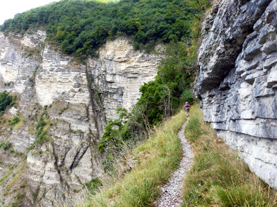
At the end of this ledge, the path starts to traverse north away from the gorge and the sound of the waterfall, and meanders pleasantly up the slopes. The path then reaches a line of cliffs where there has been a rockfall in recent times, and follows ledges with fine views into the valley below, all the way to the climbing school marked on the map. Note, the path marked on the IGN map takes a totally different line. At the end of this, it turns back on itself, and ascends through a small gorge, where there are a number of information boards about the geology and the climbing, onto the plateau.
That's the main fun over. It's worth turning right at the junction, and following this track through the woods and hayfields to la Tournoud, where there are wonderful views of the south pillar of Dent de Crolles, Chamechaude and Bec Charvet. We spotted some yellow broomrape in perfect condition in these woods.
Although we are obliged to retrace our steps back to the car, I can promise that the route down is as enjoyable as the ascent.