
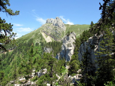
Dôme de Bellefont from Perquelin
Starting point: Perquelin Difficulty: 3 Ascent: 1000 m Time: 6½ hrs Quality: ***
One of the main features of this walk is the exploration of a route through the Chaos de Bellefont, a maze of crevasses, huge boulders, and cliffs through which a well-marked path somehow manages to negotiate. It includes a couple of scrambles, and so for that reason has been given a Difficulty 3 grading. However, this section can be easily avoided as described below. The walk starts from Perquelin, and makes its way up to the GR9 running along the Dent de Crolles prairie to the Col de Bellefont. It then follows the ridge up to the Dôme de Bellefont. A return is made along the south ridge overlooking the Grésivaudan valley as far as the Pas de Rocheplan. A descent is then made back to the GR9 at le Prayet, from where the Sentier du Colonel is followed back towards the car (map). Water is available half-way round near the Cabane de Bellefont, so you don't need to carry too much. Note that even the yellow signposts vary between the spellings Bellefond and Bellefont, so take your choice. The IGN use the latter spelling.
The Perquelin valley is a narrow valley that runs south-east from St. Pierre de Chartreuse for about three kilometres to the hamlet of Perquelin. Drive to the top of the road, and at its conclusion, continue along the forest track for 100 metres, where you will find a car park (990 m grid ref. UTM 31T 72314 50237. Our first target is to find the bottom of the Sentier du Colonel.
From the car park follow the forest track past a clearing, until you cross the Guiers Mort stream, and also get a glimpse of its waterfall above. Immediately on the other side of the bridge, a yellow signposted path ascends pleasantly through the woods, passing the Fontaine Noire (also known as the Ruisseau de Bellefont) - a captured water source which is the resurgence for the Chaos of Bellefont area above.
Continue on the path uphill for a few minutes, then take the next junction to the left (straight on leads to the Grotte du Guiers Mort), which soon leads onto a forest track. Head across this onto the Sentier du Colonel. This superbly made path rises through the forest in long, sweeping zigzags for 45 minutes, before entering a steep 50 m-wide gully. At the top of this the main path sweeps round to the right under high cliffs on its way up to le Prayet on the GR9, whilst ours goes off to the left as indicated by red paint on a boulder. (If you want to leave the excitements that await in the Chaos de Bellefont for another day, continue up to the GR9 and turn left. The path from the Chaos enters from the left 15 minutes later.)
Our path goes round the nose of the cliff from the painted boulder and heads north along the base of the cliffs, unfortunately losing height as it does so. After 15 minutes there is a junction - one path heads up a steepish and greasy gully, and the other continues straight on. The former finishes at the bottom of le Prayet meadow; we follow the latter. A few minutes later we enter the Chaos, and become totally dependent on the bold arrows and occasional cairn to guide us through the complex maze of giant boulders, cliffs, and crevasses. Make sure that you keep at least one waymark in sight at all times.
Some twenty minutes after entering the Chaos, we reach the final obstacle - the Z-Couloir, so called because it is a deep rock crevasse that has two sharp bends in it giving it the shape of the letter 'Z'. It is entered by clambering up a 4-metre scramble, with a shaft on the left ready to swallow the unwary. From here the path crosses a couple of further shafts bridged with tree branches as it goes round the first corner, and continues easily to the second corner where yet another shaft blocks the way straight ahead. The third arm of the couloir is on the right, and here it is necessary to almost immediately climb up 3 metres onto a chockstone wedged in the crevasse, and from there scramble easily right onto a wide, but exposed platform. At the far end of this an easy descent leads back onto the path proper. The difficulties are now over, although you should continue to be vigilant in following the waymarks. The GR9 is reached after ten minutes or so.
The way is now straightforward. Follow the GR9 for ten minutes to reach the Bellefont pasture, followed by a junction a couple of minutes later. If you require water, a source will found to the left near the Cabane de Bellefont after 200 metres. Otherwise turn right towards the zigzags. The 300 m ascent up to the col follows gentle zigzags, and takes half an hour or so. At the top there are some fine views looking down into the Vallon de Marcieu, with the Lance Sud de Malissard on the left of the col, and our destination ten minutes to the right. The summit is a little way to the north when the main ridge is reached. It's a lovely little top, with fine views especially of the Belledonne.
Our way back is to follow the ridge south. This is a fine walk with great views down into the valley. Some care is required with picking the right line, and at one point a scrambly descent of some 10 m is not immediately obvious from the top. The Pas de Rocheplan is reached after an hour from the Dôme de Bellefont, and may be recognised by its characteristic pinnacle, and its complex of signposts. From here we need to descend back to the GR9, but ignore the signposted path which returns to the Chaos. Instead carry on south along the ridge path for a few minutes until an obvious path starts to descend down a gully on the right. This arrives at the GR9 after ten minutes just 80 metres south of the well decorated tree in the le Prayet pasture. Once at the tree look for a path going left into the cirque - the Sentier du Colonel. This starts with a couple of short steep gullies, before swinging round under a cliff, at the end of which we meet our ascent path. Now simply retrace your steps back to the car.